Aerial geolocalization (roads & intersections)
Aerial images with road and intersection annotations, for locating an image without GPS (BMVC 2016).
Aerial RGB, Road / intersection labels, GPS
Drone footage is hard to label. Objects show up at very different scales and angles, the light changes from one flight to the next, and annotating every pixel of a 4K frame takes a long time. Since 2016 we have tried to need fewer of those labels. The early papers used local and global context to find buildings and roads in satellite images. Later ones extracted road graphs, located an aerial image without GPS by matching roads and intersections, and estimated depth and safe landing areas from synthetic 3D reconstructions.
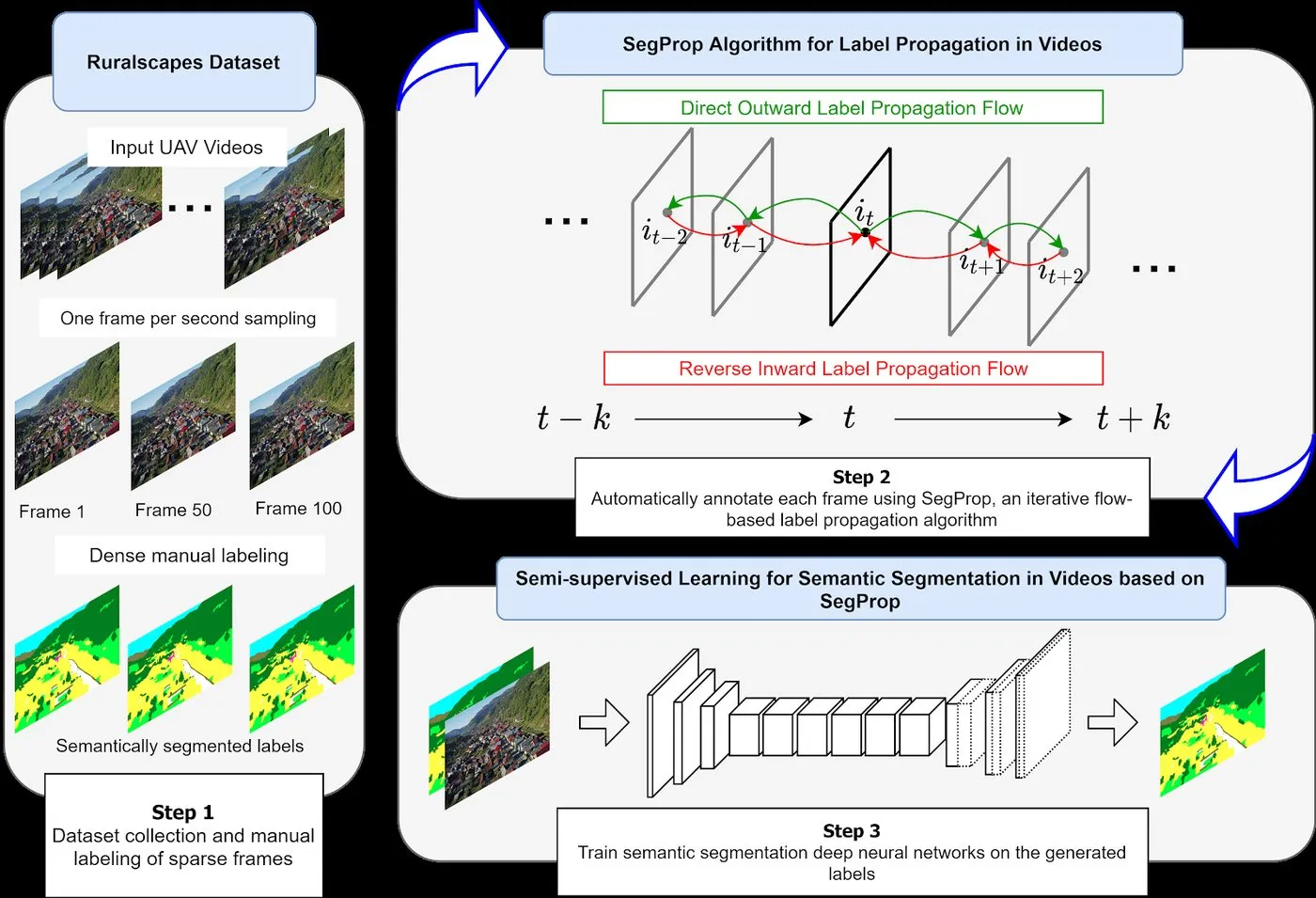
Ruralscapes is a 4K aerial video dataset of rural Romania that we labelled densely every 50 frames. SegProp, introduced with it, propagates those sparse labels to every frame using optical flow, and is closely related to spectral clustering in space and time. UFO Depth and Depth Distillation learn metric depth with no depth ground truth at all, from agreement between the drone’s odometry, optical flow and a network’s predictions.
Current work looks at semi-supervised segmentation over time, localization and obstacle avoidance from synthetic data on embedded GPUs, and how large the gap between synthetic and real aerial images actually is.
Aerial images with road and intersection annotations, for locating an image without GPS (BMVC 2016).
Aerial RGB, Road / intersection labels, GPS
Drone videos with human-annotated semantic segmentation, SfM depth and surface normals, recorded over several scenes in Romania and Norway.
RGB video, 8-class semantics, SfM depth, Surface normals, Optical flow, Edges
Satellite images of European cities with building masks.
Satellite RGB, Building masks
Satellite images of European cities with road masks.
Satellite RGB, Road masks
4K aerial videos of rural Romania with dense manual labels every 50 frames. When we released it, it was the largest aerial video dataset for semantic segmentation.
4K aerial video, Dense semantic labels every 50 frames, 12 classes
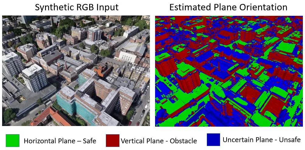
Synthetic aerial images rendered from 3D reconstructions of real places, with depth and safe-landing labels.
Synthetic RGB, Depth, Plane orientation / safe-landing labels
Drone flights with synchronized telemetry, used to learn metric depth without depth ground truth (ICRA 2022, CVPR 2021 Workshops).
Drone video, Kinematics / odometry, Optical flow, Metric depth
arXiv preprint, 2024
Quantifying the gap between synthetic and real-world imagery is essential for improving both transformer-based models - that rely on large volumes of data - and datasets, especially in underexplored domains like aerial scene understanding where the potential impact is significant. This paper introduces a novel methodology for scene complexity assessment using Multi-Model Consensus Metric (MMCM) and depth-based structural metrics, enabling a robust evaluation of perceptual and structural disparities between domains. Our experimental analysis, utilizing real-world (Dronescapes) and synthetic (Skyscenes) datasets, demonstrates that real-world scenes generally exhibit higher consensus among state-of-the-art vision transformers, while synthetic scenes show greater variability and challenge model adaptability. The results underline the inherent complexities and domain gaps, emphasizing the need for enhanced simulation fidelity and model generalization. This work provides critical insights into the interplay between domain characteristics and model performance, offering a pathway for improved domain adaptation strategies in aerial scene understanding.
Proceedings of the IEEE International Conference on Robotics and Automation (ICRA), 2022
We propose an efficient method for unsupervised learning of metric depth estimation from a single image in the context of unconstrained videos captured from UAVs. We combine the accuracy of an analytical solution based on odometry with the power of deep learning. First, we show how to correct the noisy odometric measurements by optimizing the alignment between the derotated optical flow and the projected linear speed in the image. Then, we detail an analytical depth estimation method based on optical flow and corrected camera velocities. Subsequently, the improved depth and camera veloc-ities obtained analytically are used, as additional cost terms, for training our novel unsupervised learning architecture for metric depth estimation. We extensively test on a recent UAV dataset, which we significantly extend by adding completely novel scenes. We outperform by significant margins different kinds of state-of-the-art approaches, ranging from analytical and unsupervised solutions to transformer-based architectures that require heavy computation and pre-training. The resulting algorithm could be deployed on embedded devices, being a good candidate for practical robotics use cases, such as obstacle avoidance and safe landing for UAV s.
Proceedings of the IEEE/CVF Conference on Computer Vision and Pattern Recognition Workshops (CVPRW), 2021, EVW workshop
Estimating precise metric depth is an essential task for UAV navigation, which is very difficult to learn unsupervised without access to odometry. At the same time, depth recovery from kinematics and optical flow is mathematically precise, but less numerically stable and robust, especially in the focus of expansion areas. We propose a model that combines the analytical, vision-with-odometry approach, with deep unsupervised learning, into a single formulation for metric depth estimation, which is both fast and accurate. The two pathways – analytical and data-driven – form a robust ensemble, which provides supervisory signal to a single deep net that distills the consensus between scene geometry, pose, kinematics, camera intrinsics and the input RGB. The distilled net has low runtime and memory costs, being suitable for embedded devices. We validate our results against an off-the-shelf SfM-based solution. We also introduce a new real-world dataset of almost 20 minutes of continuous UAV flight, on which we demonstrate better accuracy and capabilities than the deep learning and analytical approaches.
arXiv preprint, 2020
We propose a method at the intersection of Computer Vision and Computer Graphics fields, which automatically generates RGBD images using neural networks, based on previously seen and synchronized video, depth and pose signals. Since the models must be able to reconstruct both texture (RGB) and structure (Depth), it creates an implicit representation of the scene, as opposed to explicit ones, such as meshes or point clouds. The process can be thought of as neural rendering, where we obtain a function f : Pose -> RGBD, which we can use to navigate through the generated scene, similarly to graphics simulations. We introduce two new datasets, one based on synthetic data with full ground truth information, while the other one being recorded from a drone flight in an university campus, using only video and GPS signals. Finally, we propose a fully unsupervised method of generating datasets from videos alone, in order to train the Pose2RGBD networks. Code and datasets are available at:: https://gitlab.com/mihaicristianpirvu/pose2rgbd.
Proceedings of the European Conference on Computer Vision Workshops (ECCVW), 2020, EVW workshop
Summary (the publisher’s abstract is not openly available): Presents a real-time pipeline for detecting multiple targets in the wild from a moving 360° panoramic camera, addressing the distortions and wide field of view of omnidirectional imagery for embedded, on-board use (Embedded Vision Workshop, ECCV 2020).
Proceedings of the Asian Conference on Computer Vision (ACCV), 2020, oral
Semantic segmentation is a crucial task for robot navigation and safety. However, current supervised methods require a large amount of pixelwise annotations to yield accurate results. Labeling is a tedious and time consuming process that has hampered progress in low altitude UAV applications. This paper makes an important step towards automatic annotation by introducing SegProp, a novel iterative flow-based method, with a direct connection to spectral clustering in space and time, to propagate the semantic labels to frames that lack human annotations. The labels are further used in semi-supervised learning scenarios. Motivated by the lack of a large video aerial dataset, we also introduce Ruralscapes, a new dataset with high resolution (4K) images and manually-annotated dense labels every 50 frames - the largest of its kind, to the best of our knowledge. Our novel SegProp automatically annotates the remaining unlabeled 98% of frames with an accuracy exceeding 90% (F-measure), significantly outperforming other state-of-the-art label propagation methods. Moreover, when integrating other methods as modules inside SegProp’s iterative label propagation loop, we achieve a significant boost over the baseline labels. Finally, we test SegProp in a full semi-supervised setting: we train several state-of-the-art deep neural networks on the SegProp-automatically-labeled training frames and test them on completely novel videos. We convincingly demonstrate, every time, a significant improvement over the supervised scenario.
arXiv preprint, 2019
Semantic segmentation is a crucial task for robot navigation and safety. However, it requires huge amounts of pixelwise annotations to yield accurate results. While recent progress in computer vision algorithms has been heavily boosted by large ground-level datasets, the labeling time has hampered progress in low altitude UAV applications, mostly due to the difficulty imposed by large object scales and pose variations. Motivated by the lack of a large video aerial dataset, we introduce a new one, with high resolution (4K) images and manually-annotated dense labels every 50 frames. To help the video labeling process, we make an important step towards automatic annotation and propose SegProp, an iterative flow-based method with geometric constrains to propagate the semantic labels to frames that lack human annotations. This results in a dataset with more than 50k annotated frames - the largest of its kind, to the best of our knowledge. Our experiments show that SegProp surpasses current state-of-the-art label propagation methods by a significant margin. Furthermore, when training a semantic segmentation deep neural net using the automatically annotated frames, we obtain a compelling overall performance boost at test time of 16.8% mean F-measure over a baseline trained only with manually-labeled frames. Our Ruralscapes dataset, the label propagation code and a fast segmentation tool are available at our website: https://sites.google.com/site/aerialimageunderstanding/
Transylvanian Machine Learning Summer School (TMLSS), 2018, poster
Semantic segmentation and vision-based geolocalization in aerial images are challenging tasks in computer vision. Due to the advent of deep convolutional nets and the availability of relatively low cost UAVs, they are currently generating a growing attention in the field. We propose a novel multi-task multi-stage neural network that is able to handle the two problems at the same time, in a single forward pass. The first stage of our network predicts pixelwise class labels, while the second stage provides a precise location using two branches. One branch uses a regression network, while the other is used to predict a location map trained as a segmentation task. From a structural point of view, our architecture uses encoder-decoder modules at each stage, having the same encoder structure re-used. Furthermore, its size is limited to be tractable on an embedded GPU. We achieve commercial GPS-level localization accuracy from satellite images with spatial resolution of 1 square meter per pixel in a city-wide area of interest. On the task of semantic segmentation, we obtain state-of-the-art results on two challenging datasets, the Inria Aerial Image Labeling dataset and Massachusetts Buildings.
Proceedings of the IEEE/CVF Conference on Computer Vision and Pattern Recognition Workshops (CVPRW), 2018, DeepGlobe workshop
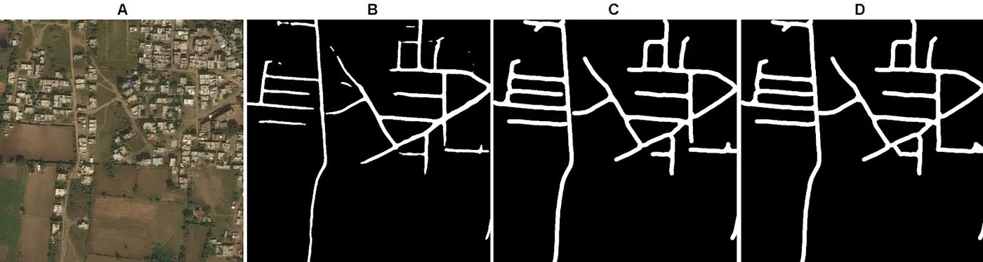
Road detection from aerial images is a challenging task for humans and machines alike. Occlusion, the lack of visual cues and slim class borders for other road-like structures (such as pathways or private alleys) make the problem inherently ambiguous, requiring logic that goes beyond the input image. We propose a three-stage method for the task of road segmentation - first, an ensemble of multiple U-Net like CNNs generate binary road masks. Second, another CNN learns to refine roads segmentations based on the fusion of the road maps from the first stage. Third, missing links are added based on the inferred graph to improve segmentation.
Proceedings of the European Conference on Computer Vision Workshops (ECCVW), 2018, UAVision workshop, oral
The emergence of relatively low cost UAVs has prompted a global concern about the safe operation of such devices. Since most of them can ‘autonomously’ fly by means of GPS way-points, the lack of a higher logic for emergency scenarios leads to an abundance of incidents involving property or personal injury. In order to tackle this problem, we propose a small, embeddable ConvNet for both depth and safe landing area estimation. Furthermore, since labeled training data in the 3D aerial field is scarce and ground images are unsuitable, we capture a novel synthetic aerial 3D dataset obtained from 3D reconstructions. We use the synthetic data to learn to estimate depth from in-flight images and segment them into ‘safe-landing’ and ‘obstacle’ regions. Our experiments demonstrate compelling results in practice on both synthetic data and real RGB drone footage.
Proceedings of the IEEE/CVF International Conference on Computer Vision Workshops (ICCVW), 2017, UAVision workshop, oralBest Presentation Award
Recognizing roads and intersections in aerial images is a challenging problem in computer vision with many real world applications, such as localization and navigation for unmanned aerial vehicles (UAVs). The problem is currently gaining momentum in computer vision and is still far from being solved. While recent approaches have greatly improved due to the advances in deep learning, they provide only pixel-level semantic segmentations. In this paper, we argue that roads and intersections should be recognized at the higher semantic level of road graphs - with roads being edges that connect nodes. Towards this goal we present a method consisting of two stages. During the first stage, we detect roads and intersections with a novel, dual-hop generative adversarial network (DH-GAN) that segments images at the level of pixels. At the second stage, given the pixelwise road segmentation, we find its best covering road graph by applying a smoothing-based graph optimization procedure. Our approach is able to outperform recent published methods and baselines on a large dataset with European roads.
Proceedings of the AAAI Conference on Artificial Intelligence Workshops (AAAIW), 2017, AI-CAV workshop, oral
The importance of visual context in object recognition has been intensively studied over the years. Along with the advent of deep convolutional neural networks (CNN), using contextual information with such systems starts to receive attention in the literature. Regardless of deep learning advances, aerial image analysis still poses many great challenges. Satellite images are often taken under poor lighting conditions and contain low resolution objects, many times occluded. For this particular task, visual context could be of great help, but there are still very few papers that consider context in aerial image understanding.Our work addresses the task of object segmentation in aerial images with a novel dual-stream deep convolutional neural network that integrates the local object appearance and global contextual information into a unified network. Our model learns to combine local object appearance and global semantic knowledge simultaneously and in a complementary way, so that together they form a powerful classifier. Experiments on the Massachusetts Buildings Dataset demonstrate the superiority of our model over state-of-the-art methods. We also introduce two new challenging datasets for the task of buildings and road segmentation. While our local-global model could also be useful in general recognition tasks, we clearly demonstrate the effectiveness of visual context in conjunction with deep nets in aerial image understanding.
arXiv preprint, 2016
Aerial images are often taken under poor lighting conditions and contain low resolution objects, many times occluded by other objects. In this domain, visual context could be of great help, but there are still very few papers that consider context in aerial image understanding and still remains an open problem in computer vision. We propose a dual-stream deep neural network that processes information along two independent pathways. Our model learns to combine local and global appearance in a complementary way, such that together form a powerful classifier. We test our dual-stream network on the task of buildings segmentation in aerial images and obtain state-of-the-art results on the Massachusetts Buildings Dataset. We study the relative importance of local appearance versus the larger scene, as well as their performance in combination on three new buildings datasets. We clearly demonstrate the effectiveness of visual context in conjunction with deep neural networks for aerial image understanding.
Proceedings of the British Machine Vision Conference (BMVC), 2016, poster
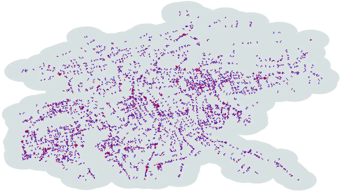
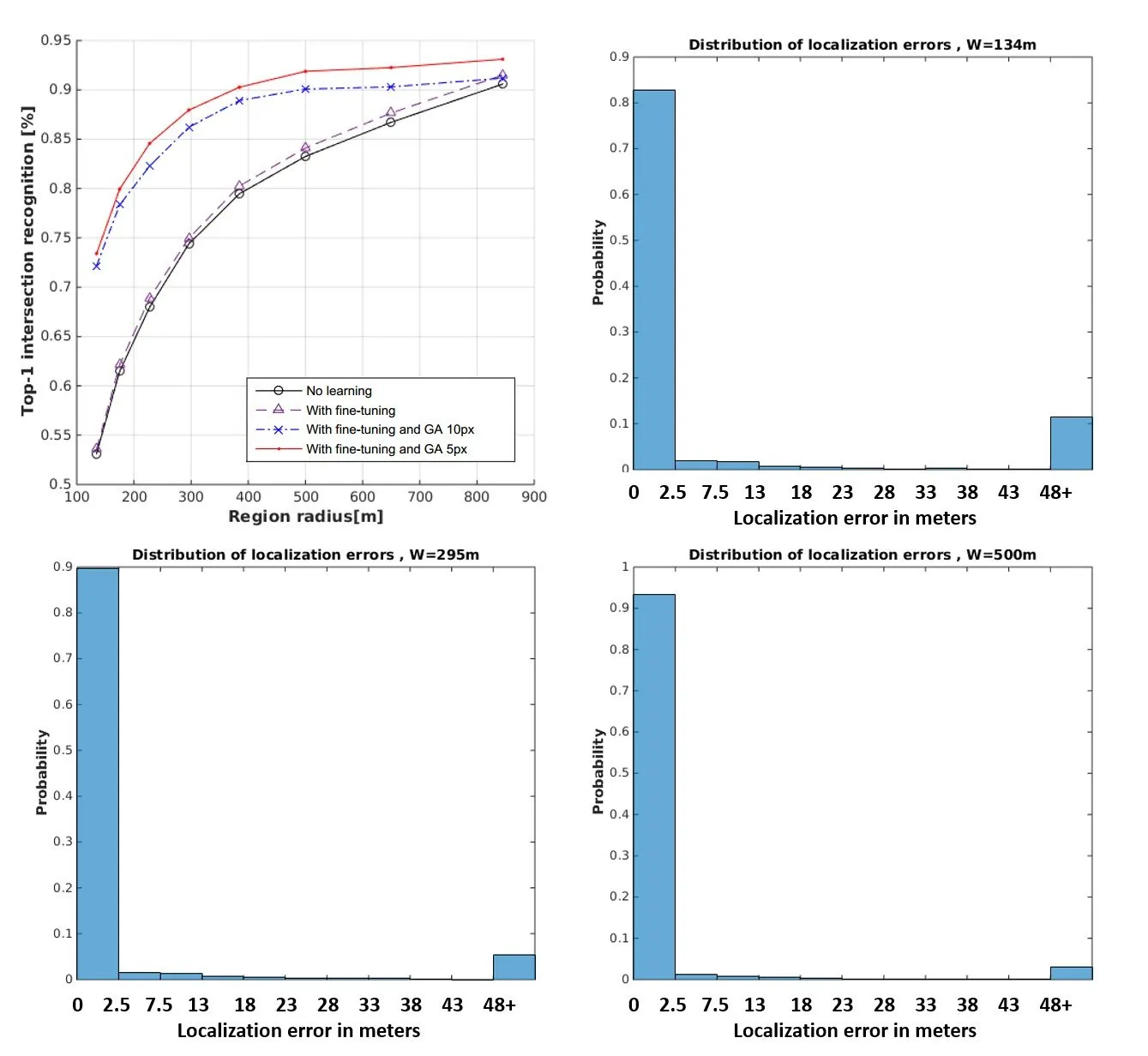
Aerial image analysis at a semantic level is important in many applications with strong potential impact in industry and consumer use, such as automated mapping, urban planning, real estate and environment monitoring, or disaster relief. The problem is enjoying a great interest in computer vision and remote sensing, due to increased computer power and improvement in automated image understanding algorithms. In this paper we address the task of automatic geolocalization of aerial images from recognition and matching of roads and intersections. Our proposed method is a novel contribution in the literature that could enable many applications of aerial image analysis when GPS data is not available. We offer a complete pipeline for geolocalization, from the detection of roads and intersections, to the identification of the enclosing geographic region by matching detected intersections to previously learned manually labeled ones, followed by accurate geometric alignment between the detected roads and the manually labeled maps. We test on a novel dataset with aerial images of two European cities and use the publicly available OpenStreetMap project for collecting ground truth roads annotations. We show in extensive experiments that our approach produces highly accurate localizations in the challenging case when we train on images from one city and test on the other and the quality of the aerial images is relatively poor. We also show that the the alignment between detected roads and pre-stored manual annotations can be effectively used for improving the quality of the road detection results.
arXiv preprint, 2016
Visual context is important in object recognition and it is still an open problem in computer vision. Along with the advent of deep convolutional neural networks (CNN), using contextual information with such systems starts to receive attention in the literature. At the same time, aerial imagery is gaining momentum. While advances in deep learning make good progress in aerial image analysis, this problem still poses many great challenges. Aerial images are often taken under poor lighting conditions and contain low resolution objects, many times occluded by trees or taller buildings. In this domain, in particular, visual context could be of great help, but there are still very few papers that consider context in aerial image understanding. Here we introduce context as a complementary way of recognizing objects. We propose a dual-stream deep neural network model that processes information along two independent pathways, one for local and another for global visual reasoning. The two are later combined in the final layers of processing. Our model learns to combine local object appearance as well as information from the larger scene at the same time and in a complementary way, such that together they form a powerful classifier. We test our dual-stream network on the task of segmentation of buildings and roads in aerial images and obtain state-of-the-art results on the Massachusetts Buildings Dataset. We also introduce two new datasets, for buildings and road segmentation, respectively, and study the relative importance of local appearance vs. the larger scene, as well as their performance in combination. While our local-global model could also be useful in general recognition tasks, we clearly demonstrate the effectiveness of visual context in conjunction with deep nets for aerial image understanding.